Quick Search
Browse:
Town Info:
Walking
Bushwalking & Picnics in the Harvey Shire
Wildflower Picnic Site
Honeymoon Road, Harvey. Length 1.4km.
Wildflower Picnic Site is classed as easy walking and a beautiful walk trail. Follow the small white circles marked on the trunks of trees. Wildflowers in abundance. Pets allowed.
Hoffman Mill – Picnic & Campsite
Clarke Road, Harvey. Bridge Trail – Length 3km.
Blue markers indicate the route. This begins a short distance from the information shelter. Plenty of wildlife, once home to the rare and noisy Scrub Bird.
Formation Trail – Length 650m
An easy walk which follows the railway formation and Harvey River through the Jarrah forrest. No pets allowed. Picnic and campsite, approximately 13kms east of Logue Brook Dam Visit the site of this old timber milling town, which only closed in the historic town of Yarloop is a gem for lovers of all things rustic!
Leschenault Peninsula Conservation Park Australind
Belvidere Estuary Walk – Length 4km. Starts at Belvidere carpark and heads east.
Cycling and walking only permitted over large sections of the park. Long or short circuits walks. Many species of birds.
Belvidere Interpretive Walk – Length 1.5km.
This walk documents the rich cultural history of Belvidere and is a perfect place for a picnic or barbeque. The trail provides and excellent location for bird watching with a vast array of water birds frequenting the shallows of the Leschenault Estuary.
John Boyle O’Reilly Wetland Trail – Length 1 km return.
Learn more about the plants and animals of this park as you meander through tuart, peppermint and paperbark trees. At the information shelter, discover how the Irish convict John Boyle O’Reilly made his daring escape into the bush here from a ship named the Gazelle in 1869.
Harris Track – Length 9km.
The Harris Track stretches south 9 kilometres from Belvidere to “The Cut”, a channel joining the Leschenault Estuary and the Indian Ocean. The path winds through tuart and peppermint woodland along the coastal dune ridge. Walkers can enjoy panoramic views across the Leschenault Estuary to the Darling Scarp and across the Indian Ocean. Along the path you may see kangaroos, lizards and many birds including Carnaby’s black cockatoo, pelicans and the black shouldered kite. Australind’s Bottlenose dolphins are regular visitors to water at “The Cut”. At the start of the track, Western ringtail and Brushtail possums are often seen in the campground at night.
Heron Walk Trail
Located on the east side of the Old Coast Road adjacent to Buffalo Road. View the wetland in the heron haven. There is an information centre at the start of the walk. Picnic table and carpark.
Wetland Wonders Walk
Located at Westgarth Place, Leschenault off Cathedral Avenue’s Scenic Drive.
Only minutes from Australind, the Wetland Wonders Walk at Rosamel Wetlands, is a haven for water birds and wetland wildlife. The Wetland Wonders Walk is an easy and peaceful stroll favoured by both the friendly locals and visitors. Sustaining a rich diversity of plant and small animal life in a tranquil setting. The Wetland Wonders Walk offers opportunities to relax, take in your surroundings and enjoy watching some of the local birds in full flight.
Some Varieties;
- Black swan
- Shelduck
- Pacific black duck
- Sacred ibis
- Great egret
Through the Ribbons of Blue program and the Shire of Harvey, volunteers have been engaged to rehabilitate this wetland. This site has been escavated to expose the water table and attract water birds and increase the biodiversity of the area. Interpretive shelters are located around the Wetland Wonders Walk.
Lake Preston
Yalgorup National Park, Myalup. Heathland walk – Length 4.5km.
Travel north along the Old Coast Road. Travel 5km down this road until you reach Lake Hayward. Start at the Information Bay on Preston Beach Road and head west along the track signposted as Caves Road. Follow the markers to complete the circuit walk.
Lake Pollard Trail
Length 6km
Travel north 1.5km from Lake Hayward to reach Lake Pollard. The walk starts at the entrance to Martin’s Tank Campground on Preston Beach Road. Follow the yellow pointers.
Harvey Heritage Trail
From the 1830’s the Harvey area was known as “Korijekup” the Aboriginal word meaning “The place of the Red Tailed Black Cockatoo.” Early explorers named the Harvey River and by the 1890’s the Korijekup Estate become known as Harvey Estate. As the township took shape near the turn of the century, it became known as Harvey.
Download the Harvey Heritage Trail brochure and map. Also availbale from the Harvey Visitor Centre and the Australind Information Centre.
Harvey Tourist Precinct River Walk
This is an easy scenic walk that follows the Harvey River and is surrounded by Heritage Gardens.
The walk starts to the left-hand side of the Harvey Visitor Centre and continues past Stirling Cottage. After this, turn left and go past the water fountain towards the start of the river path. Follow the path around the river and if you wish to stop, there is a set of limestone steps to the right where a grassed area and picnic tables are located. Continue along the path until you see Lockwood Falls and the gazebo to the left. From there, you can either go over the foot bridge and under the highway towards town or just continue straight back towards the carpark.
Australind Heritage Trail
Download the Australind Heritage Trail brochure and map. Also available from the Harvey Visitor Centre and The Australind Information Centre.
OTHER HISTORICAL PLAQUES
9. Benjamin and James Piggott– near Australind Shire Office Early pioneers.
10. Australind State School– 1.4km Cathedral Avenue/Scenic Drive.
11. Parkfield School– 10km- Buffalo Road. Just past the stand of trees.
Brunswick River Walk
Distance: 4km. Average Time: 45 minutes.
Take an enjoyable walk beginning from Pioneer Park and follow the winding Brunswick River situated on the outskirts of quaint Brunswick Junction. A gravel path guides the way, with interpretive information and seating provided. Rejoin the town’s dual use pathway network and pass by many well-known tourist icons including the Brunswick Oval, Dairy Factory and famous Brunswick Cow On The Corner – Daisy. This walk is suitable to most ages and abilities although the river section may need to be avoided by those with mobility problems.
To view a map of this walk please click here.
Brunswick Hillview Walk
Distance: 4.2km. Average Time: 50 minutes.
The Brunswick Lesser Hall is the start and finish point for this “around-town” walk. The walk incorporates most of the town’s pathways but also includes several other surfaces including a short stretch of gravel. Walkers will be able to get a real feel for the town as they make their way through many residential streets often encountering a friendly “hello” or similar greeting from locals. This enjoyable walk provides a snapshot of Brunswick’s diversity including scenic hills to the east and the Brunswick Channel and Community Park.
To view a map of this walk please click here.
Beela Road Walk – Brunswick
Distance: 5.3km. Average Time: 1 hour.
Beginning from Lions Park, home of the “most photographed cow in Australia”, this walk is quite challenging as it traverses the rolling hills to the east of Brunswick. An “out and back” walk set totally on Beela Road, walkers can challenge themselves by increasing the distance each time they set out. If desired, certain sections of the walk can incorporate gravel roads alongside the railway line however these can be quite wet and muddy during winter. Beela Road is a spectacularly scenic walk, especially during winter and spring.
Friesian Frollick – Harvey
Distance: 3.8km. Average Time: 40 minutes.
The “Friesian” Frollick is named after a common breed of dairy cattle and the black and white cows can often be seen grazing in the paddocks bordering this walk. Starting at the Harvey Town Hall, Friesian Frollick winds its way out of town, passing the local Community Radio Station and Harvey Primary School before moving into an area of lush irrigated paddocks and citrus orchards. Much of the walk utilizes the road surface or verge, but closer to town dual use pathways are available. An excellent walk to experience the rural and residential diversity that Harvey has to offer.
Simmental Stroll – Harvey
Distance: 4.1km. Average Time: 45 minutes.
Beginning and ending at the Harvey Recreation and Cultural Centre, Simmental Stroll is an enjoyable and user friendly walk for all ages. Taking in the sights of Harvey’s main street including the historic Library Building, Town Hall and Street Murals before moving on to farming areas on the outskirts of town, Simmental Stroll passes both of the town’s Primary Schools, Shire Council Offices and CBD. This walk is mostly on dual use paths suitable for people in wheelchairs, on gophers or pushing prams.
Harvey Visitor Centre Walk – Harvey
Distance: 4.4km. Average Time: 50 minutes.
Starting from the Harvey Visitor Centre on South-West Highway, this is an interesting and enjoyable walk on a variety of walking paths and surfaces. Walkers pass by many local attractions including the Harvey River and “man-made” River Diversion, street murals, Harvey Railway Station Museum and historic Harvey Hotel / Motel. Much of the walk occurs on concrete pathways but some road verge and limestone paths are encountered. Walkers with mobility difficulties may find the first sections (unsealed) of the walk slightly challenging, but there is the option of starting on the western side of the highway in the carpark before the bridge.
Dick Lofthouse Rotary Walk / Harvey Dam & Amphitheatre Walk
Distance: 1.9km. Average Time: 25 minutes.
Enjoy the breathtaking views and majestic surrounds associated with the $275 million Harvey Dam & Amphitheatre development. Although relatively short in distance, this walk is quite physically taxing and is not suitable to those with mobility difficulties. The walk begins and ends from the Amphitheatre facility and involves climbing a number of metal steps to the top of the dam wall and a steep decline upon re-entry to the park area.
The world class venue includes a children’s playground, toilets and access to free gas BBQ’s. In the early 1980’s, a group of Rotarians from Harvey led by Dick Lofthouse decided to create a bush walk within the precincts of the Harvey Dam. This walkway was maintained for many years by Dick until it was absorbed into the new Harvey dam development. In recognition of the foresight and work of Dick and other Rotarians a new walkway has been constructed. The ‘Dick Lofthouse Rotary Walk’ acknowledges the enormous contribution made to the Harvey community. Enjoy the natural bushland and dam along the walk.
Bibbulmun Track – Harvey Access Point
Harvey Quindanning Road by Long Gully Bridge.
Phone: Harvey Visitor Centre 08 9729 1122.
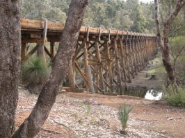
Bibbulmun Track access is available at Harvey. To access the Bibbulum Track from the Harvey Visitor Centre, turn left into South Western Highway, travel south approximately 1km and turn left into Weir Road. You are now travelling east. From the Harvey Dam turnoff the road changes name from Weir Road to the Harvey-Quindanning Road. From this turnoff to the Stirling Dam turnoff, it is approximately 6.8kms. From the Stirling Dam turnoff, travel 3.6kms and this is where the bitumen ends and the gravel begins. Travel along the Harvey-Quindanning Road for 35.5kms until you see on your left, the historic and wonderful Long Gully railway trestle bridge.
The Long Gully Bridge across the Murray River is a rare example of a curved railway bridge and is the largest and most significant wooden trestle bridge in the northern jarrah forest. The Long Gully Bridge offers good vehicle access for the first time south of Dwellingup and is the starting point if you are walking the section from Harvey to Collie. Look for the yellow triangular markers, symbolising the Waugul, the rainbow serpent of the Aboriginal Dreaming.
The famous Bibbulmun Track stretches from Perth to Albany for 967km. Approximately every 20km along the trail there are campsites, tent sites, huts, sleeping platforms, toilets and water tanks. It is advised to bring your own fuel stove in case of fire bans etc. Don’t forget something to light the stove with or you may have to rub sticks together to get it started.
The track is marked with triangular yellow markers but it is advised to carry a map with you and some insect repellent.